The Cochituate Rail Trail is a
proposed 4-mile
recreation
and transportation corridor which will extend from Natick Center to the
village of Saxonville in Framingham. It will provide walkers, joggers,
cyclists, and many others with safe and pleasant access to Cochituate
State
Park as well as to many businesses and offices in Natick and
Framingham.
There will be a side trail west to the tremendously popular
Natick Mall, General Cinema, and Shopper's World area. Another spur
will
head east into Wayland. Since the CRT will connect to the Natick
commuter
rail station, the potential exists for a substantial number of people
to
use the trail for commuting to work.
Map of
Cochituate Rail Trail
A key feature of the CRT is that it will be much more than just a bike path or a sidewalk. Like most of the 1,500 rail trails in the USA, it will be a greenway - a linear park where people can relax and enjoy the great outdoors. For most of its 4-mile length, the trail corridor will be 60 to 85 feet wide. This provides enough room for a safe trail with trees or landscaping on each side: "A greenway, not an alleyway."
The Town of Framingham was able
to begin ground work
on
the CRT earlier than Natick. Both towns and Wayland, and many other
groups,
have rallied to help Framingham begin this regional project.
As of late
2001:
Framingham has received a $20,000 DEM matching grant and a
$100,000 MassPike
Tourism Grant to help. The Framingham section of the CRT has been
minimally
cleared throughout, and there is hope that it will be operational in
Summer
2002.
In Natick, the at-grade and dangerous Lake Street railroad
crossing hosts three locomotive-utomobile collisions within a one-year
period. One truck is totalled, but no one is injured and no accident
statistics appear on the railroad safety record. CSX agrees to
reinstitute some safety precautions.
A glossy CRT brochure, "CRT-shirts", clean-ups and meetings
involve and educate the public.
As of mid-2004:
MassPike opens its fencing in anticipation of CRT use, and MassPike finally completes its lease agreement
with
Framingham. But MBTA's
approval still is awaited. Framingham
remains
unable to expend all of its initial $120,000, and unpainted bridge structures continue to deteriorate
while reconstruction materials, purchased years before, still await
that
necessary access agreement. Nissan
of Natick's service facility (on Old Connecticut Path in Framingham)
agrees to construct a stockade fence to halt repeated dumping onto the
CRT. Poison ivy is growing back, where it has been cleared in prior
years by enthusiastic volunteers. Public access is delayed for anoher
year.
In Natick, the one occasional continuing rail use is less
frequent, and will end in or before 2006. Negotiations with CSX have
begun. The CRT project is closely linked with the Natick Mall (which
plans to expand onto the Wonderbread Plant property, and to provide
major CRT funding), a new Eastern Bank building at the southern
terminus of the CRT, and all other projects that will have synergy with
this project. The CRT is a major component of Natick's 'Smart Growth"
initiative.
Aren't standard highway designs good enough?
Seldom. In typical U.S. cities, bicyclists and even pedestrians have been dialed out of highway design for many decades. Neither the roads nor traditional highway engineers are up to the task. Europe is well ahead in some respects, and some U.S. cities are starting to adopt local and foreign designs that work better.
Traditional roadway designs emphasize cars at the expense of bicyclists, pedestrians, the people who live and work alongside the roadway, and often the environment. Thus, "improvements" generally mean more cars at faster speeds. Traffic-calming techniques can be very beneficial, but often are ignored.
The professionals who design bike paths or multi-use paths, and the professionals who design the road crossings of those paths, usually share that car-centric background. More experienced bicycle and pedestrian inputs are often necessary to assure a good design for alternative transporation.
John Allen has excellent
critiques
of some old and
new
U.S. designs:
Evaluation
of some bicycle facilities and programs in Massachusetts communities.
A
realistic look at bicycle facilities, laws and programs.
Also
see:
Take
Back
Your Streets (Conservation Law Foundation, 1998)
"Go By Bike" brochure (MassDOT, 2011)
Chip Seal is newly popular as a top-coat for new or repaired pavement; with tight DPW budgets, it's seen as a way to make the surface last twice as long.
Chip sealing coats the road surface with small, sharp stone chips,
adding a rasp-like texture. That's bad news for bicycles, because it
greatly accelerates tire wear. It's bad news for kids and occasional
adults, because a fall results in far worse skin damage. And, by
increasing the fragmentation of tire particulates, it may significantly
increase
heart disease.
Maryland has been using Smooth
Seal
for similar benefits, without similar harm. But in 2004, Massachusetts
DPWs seem unaware of this, and are planning greater use of chip
seal.
Porous pavement
(one
common
form of it) is asphalt pavement that has been designed to leak. That
removes
rain and meltwater before it can freeze and crack the pavement, and it
improves safety and the environment. It even reduces road noise. And, it's less expensive: Contrary to the initial
opinions of many civil engineers, properly mixed and installed porous
pavement far
outlasts normal asphalt pavement in the harsh winter climate
of
eastern
Massachusetts.
For porous pavement, there's no better underlayment than typical railroad roadbed ballast. If the Cochituate Rail Trail gets paved, here's a pavement material that will be more safe, and which will remove its own snow and ice without expensive and environmentally-harmful road salt.
What
do you get if you add a top course of porous
pavement to the old, waterproof under layers? It's called Open-Graded
Friction Course. Although OGFC only delivers half of the
benefits
of
porous pavement, it's still so good that it's becoming the preferred
re-surfacing treatment for our nation's superhighways. Around
Natick,
you can see (and not
hear!)
early OGFC sections on Route 128 between Routes 2 and 3, and on the
Massachusetts Turnpike in Grafton and Upton.
Stone Dust can be used instead of paving. Various mixes can be added to the natural ground, to make it more durable. And, although some assume it can't work, many soils make good trail surfaces with no special treatment, or perhaps with some stone dust in the occasional muddy spot. Natural trails are easily patched by volunteers; there's no need to await major damage to justify repaving.
A natural trail surface should have good drainage to protect it from erosion. To keep rain and snow run-off from cutting through: channel running water alongside, pipe it under, or use a ford bar (or a water bar) to channel it across. Reduce or protect steep slopes.
When to pave? Very heavy urban traffic may dictate it. Paving makes inline skating possible, and speeds up bicycles (at the expense of dog walkers, baby carriages, wheelchairs and especially birdwatchers). Juxtaposing those speed differences creates additional collisions and near-collisions; bicycle-safety expert John Allen, a valued friend when it comes to safe trail design, explains that high-speed bicycling belongs on roads, not multi-use trails. Dual-speed trails (one fast path, one slow) are greatly liked where they've been tried. (We've visited good dual-speed trails in New Hampshire and Maine, and would like to see some --perhaps the CRT-- in Massachusetts.)
Raised Crosswalks (Speed Tables) and Speed Humps (not Speed Bumps):John Allen likes speed humps, and recommends their speed table version as one measure that will be helpful at some trail crossings. That's humps, not bumps. Like speed bumps, they are a traffic calming technique that can keep cars, bikes and pedestrians from tangling with each other at trail crossings. Unlike speed bumps, speed humps are more forgiving when hit at moderate speeds. John calls speed bumps "bicyclist killers", because they can cause an unwary bicyclist to fall and risk a fatal head injury.
In effect, a speed hump is a long, drawn-out speed bump on the road, ramping up and back down. If the top has significant width (say, to carry a bike trail or crosswalk up above puddles and slush), it's called a speed table or (preferred) a raised crosswalk. There will be warning triangles (chevrons) on the ramp up, and the rise is gentle enough to not throw a surprised bicyclist. Early users report that raised crosswalks work very well. They can be incorporated along the Cochituate Rail Trail; for example, where the TJX driveway entrance from Speen Street will cross the trail, at the exit driveway for Eastern Bank in downtown Natick, and perhaps at appropriate street crossings.
Attached
is John Allen's
photo of a raised
crosswalk on Columbia Street in Cambridge, MA. Other local
towns
using
raised crosswalks include Brookline, Lexington and Wellesley, MA. Some
good links for raised crosswalks are:
Traffic-Calming
Measures - Speed Table (Institute of Transportation Engineers)
Cambridge
Traffic Calming Program (Environmental &
Transportation
Planning
Div., Cambridge, MA)
Take
Back
Your Streets (Conservation Law Foundation, 1998; see "Speed
Table"
in Chap. 5)
Exception: Portland,
Oregon's "speed bumps" are speed humps.
The
current Natick Mall Expansion plan includes traffic roundabouts.
Roundabouts are not the big, fast, circular highway intersections we
call rotaries. They are smaller, traffic-calming alternatives to stop
lights and they bear special mention. I asked an expert on the subject,
Bob White of Connecticut, to shed some light on roundabouts, and found
out that he's a big fan of them when they are properly designed. Read
Bob's description, here.
We commit vast expenditures for automobiles. And that makes many crossings unnecessarily dangerous for pedestrians and bicyclists. Surely we can also invest in a few good separated-grade trail crossings. Say, one where busy Speen Street separates Natick Mall from the Cochituate Rail Trail. After all, that's where the largest mall in New England will meet one of its most popular rail trals. Both projects may arrive as early as 2007, and that's reason enough to plan now.
Traffic at that Speen Street location exceeded 43,000 vehicles
per
day in June 2002 and June 2003.
It's already higher this year, will be higher still after Natick Mall
expands to become the largest mall in New England, and that's not
even in the busiest season! Speen Street traffic also weaves more than
on Route 9 or Route 30; drivers attempting to navigate its confusions
(which include a unique rotary with no loop on its southern side!)
look up at signs, sideways and over their shoulders for
incoming vehicles, everywhere but
at a few small pedestrians or bicyclists. No wonder that, on the entire
trail route, this at-grade crossing to a major set of attractions
(multiple shopping malls, movie theatres, neighborhoods) is the one
that parents don't trust their children to cross safely.
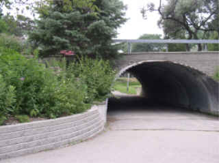
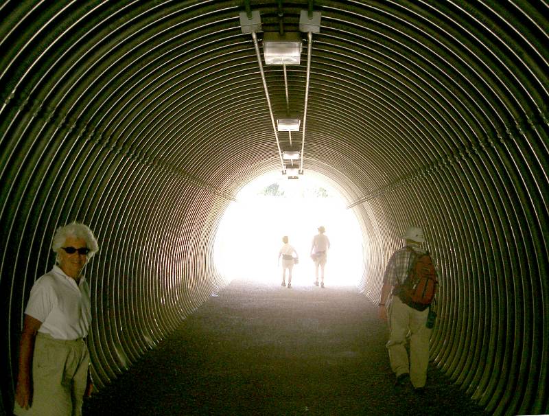
People
tend to think pedestrian
tunnels are
dangerous and
uninviting. But well-designed, well-managed tunnels are inviting -- and
far
safer than at-grade crossings. Separated-grade crossings
cause no
traffic delays;
they conserve gasoline and reduce obnoxious and unhealthful exhaust
fumes. Bridges, especially ones over depressions so they do not require ramps at the ends, can be good and even beautiful. In comparison to overpasses, tunnels are weatherproof, do not tempt stone-tossing vandals, and usually are easier to
access. (It's easier for an
18-wheeler to climb above pedestrians than vice versa.) In many
instances, tunnels
also are less expensive than overpasses. And on the CRT, a
proposed Speen Street underpass to the Natick Mall has a very
inexpensive assist: The road will be realigned and rebuilt anyway. With
good planning, cut-and-fill tunnel construction can coincide with the
already-necessary construction equipment, pavement removal and
replacement, and traffic rerouting!
John Brennan's photo shows how Seattle, WA has the Burke-Gilman Trail underpass a shopping mall entrance. And far north of Natick, in Toronto, Susan Geiser photographed this far simpler corrugated-culvert tunnel for people.
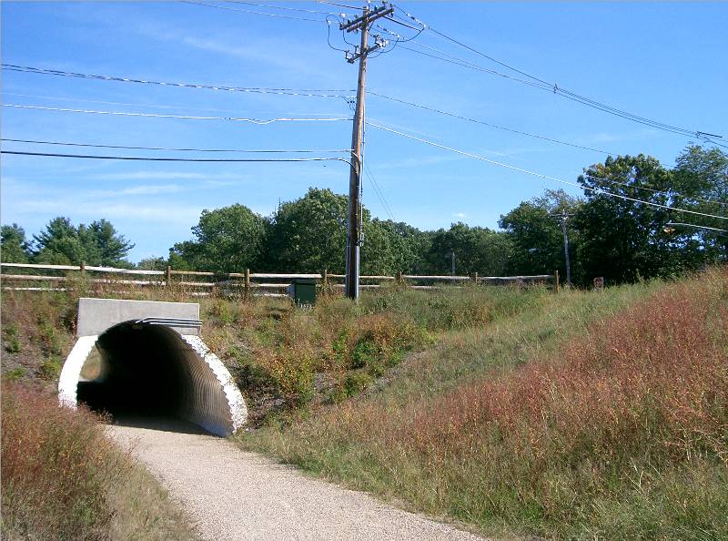
Bike-ped tunnels exist near Natick. In 2004, MassHighway constructed a moderately-expensive bicycle-pedestrian underpass on the nearby Assabet River Rail Trail (under the Route 85 Connector to Interstate 290, in Hudson at the Marlborough town line). Construction: Precast concrete modules; 85' long x 14' wide (13' at base) x 11' high. Unfortunately for bicyclists, MassHighway zigzagged the 45°-angled trail to create a perpendicular (shorter, thus cheaper) tunnel.
In 2005, the U.S. National Park Service's Minute Man National Historical Park opened its bicycle-pedestrian underpass on the Battle Road between Lexington and Concord, under Hanscom Drive just north of its Route 2A intersection in a northern corder of Lincoln, MA. Construction: Corrugated aluminum; 124' long x 9.5' wide x 11.5' high.
Like
the 75'-wide Speen Street crossing at Natick Mall, each of these nearby
tunnels is close to a
traffic-lighted intersection; these tunnels were not necessary for
connectivity.
Rather, their designers and communities consider them important for safe and inviting
connectivity.
We should provide a safe, inviting underpass for our bicyclists, pedestrians and wheelchair users here, under busy, traffic-weaving Speen Street, to link the Natick Mall (which will be the largest mall in New England) to the Cochituate Rail Trail (which, unless planners miss this opportunity, will be one of the three most popular rail trails in Massachusetts).
A great problem-solver, bicycle stairs are inexpensive, practical, and have no moving parts.
Bicycle Parking is a critical ingredient in a successful rail-trail recipe. Unless the ride is ONLY a ride, people want to get off the bike to go shopping, eat, swim, visit the library or museum or movie theater. And, on the CRT, to take the train to work. The bike can be chained to a fence, a lamppost or parking meter, or a tree, but none of those are solutions that will hold a lot of bikes in a desirable manner.Sorry; the Framingham Planning Dept. has not yet approved our use of its existing plans.
CRT Crossing at at Old Connecticut Path, Framingham:
On December 5th, 2001, a first intersection design at Old Connecticut Path was brought before the Framingham Traffic and Roadways Safety Committee to receive approval and go to 100% design stage. Both town residents and some from beyond protested that the public involvement process failed to share the description and plans in a timely manner. That committee tabled action for a month (to the second Wednesday in January), after requesting better coordination to develop a generally-supported design at the Dec. 18th meeting of the Framingham CRT Committee.
Revised plans were delivered by HTSD, Inc. two hours before the January 16th (3rd Wed.) meeting of the FTRSC. They were filed at that meeting with two cover letters, but all parties agreed further discussion would be tabled until February to allow time for public study and comment. The key parts of that information were updated here on Feb. 2nd to facilitate public review.
Several
non-Framingham
design-reviewers are already
identified,
and others are invited to join in. The following message from Bryan
Taberner,
Framingham Senior Planner includes a description of the
initially-proposed
design. Online plans and further letters follow.
Mara: Earlier today I
sent several CRT
Committee
members and FBPAC
members copies of two
main pages of the draft
intersection design (full
scale), with the short
memo below. Please
let the Planning Department
know if we can assist
you further with this
issue.
Bryan W. Taberner, Senior
Planner
Planning and Economic
Development
Town of Framingham
150 Concord Street,
Room B2
Framingham, MA
01702-8325
Phone: 508-620-4852, FAX:
508-820-9645,
E-mail:
bwt@framinghamma.org
Memorandum
To: Tom
Branham, Andy
Toorock,
Ed Kross, Mark Lamkin, Dan Smiley,
From:
Bryan W. Taberner, Senior
Planner
Re:
Intersection of
Cochituate
Rail Trail at Old Connecticut Path
Cc:
William Hanson,
FPBAC
Chair
Date:
December 7, 2001
The Planning Development has
been working
with
HTSD to develop a plan
and related
specifications to have pedestrian
cross lights and access
controlling devices
installed at the
intersection
of the CRT and Old
Connecticut
Path. Attached are two sheets
from the draft plans showing
the proposed design.
Existing plans call for the
lights to be
constantly
blinking yellow
unless a pedestrian or
bicyclist uses a
pushbutton
to activate the cross
light. A
scored cement concrete island
will
separate the pedestrian or
bicycle traffic as they
approach Old Conn
Path.
Three bollards will
restrict automobile
access; the middle bollard
would be removable and
key locked.
In addition to signage
installed
on Old Conn Path as
described in the plan,
additional signage will
be installed on the
trail. These
additional signs are not
shown
as they will not be part of
the intersection
construction contract.
If anyone has questions please
call; I'm
happy
to meet with all of you
collectively, or any of
you individually.
After presenting your input
to the CRT Development
Committee on December 18,
and gathering public
comments until and
during the December 18th
meeting,
HTSD and the
Planning Department
will update the plans and
submit them to the Safety
Committee for their
approval.
Dick Miller's comments on changes from the first round of plans:
Not yet showing on these plans, but Dick (and others?) will continue to request:Changed the lane widths at the curbs from 6' and 10', to 8' and 8' (compared to the normal trail widths of 6' and 6'; these widths do not include the 3'-minimum unobstructed run-off areas on both sides). Swung the crossing more abruptly, in order to cross the street at a more nearly perpendicular angle. Lane dividers will only be surface markings (hopefully, using non-slip paint or tape), rather than a raised concrete island approaching the street. HTDS, Inc.'s $77K estimate for full traffic signaling has resulted in a greatly scaled-back plan; all signal lighting is expected to await future-year funding.
Share your corrections and further comments, please!Continuing the path's center divider markings on the street surface. (We now are assured by State and Federal authorities that this definitely is not precluded by the design standards, and may be more desirable subject to local conditions.) Assurance that the bollards are spaced closely enough to normally block cars and trucks from the path. (Bryan Taberner's Jan. 16th letter says yes, but the bollard locations on the plan may indicate problems in this regard.) Road signage to include bicycle symbols and "Cochituate Rail Trail" logo. New "bituminous concrete" (asphalt) pavement to be porous pavement. (Porous pavement is included in Bryan Taberner's Jan. 16th letter.) Use of traffic-calming devices such as "rumble strips" on approaches to path crossing.
CRT Crossing at School Street, Framingham:
Draft plans already exist for this next major intersection design in Framingham. Detailed discussion of it has been postponed beyond the January timeframe. We expect Framingham to share that information here, in the near future.
Back to the MMS Home Page (Top)
Back to the MMS
Home Page (Links)
Please E-mail your feedback on
this
Webpage to Dick and Jill Miller at TheMillers@millermicro.com
Copyright (C) 1997-2004 by Miller
Microcomputer Services.
All Rights
Reserved.