


September
13th-19th, 2003: Off
to New York
City, to attend the incredible shrinking PC Expo - and for some
side trips as well. Old friends, new computer tricks, unusual food,
reacquaintances
with old streets and subways.
|
|
|
|
|
|
A
brief return visit to Dick's
childhood
community of Sunnyside
Gardens
in Queens,
NY found it remarkably unchanged from June
2002,
from Dick's childhood,
and probably from 1925. This 1925 planned comunity development, just a
15-minute subway ride
from Grand Central Station, is famous for its sycamore-shaded streets
and
standardized brick row housing with pedestrian alleyways leading into
quiet,
secluded communal courtyards. Close to Manhattan, residential housing
doesn't
get greener than this. The first view above is Dick's old home, 39-19
47th Street. Then, up the street (south) toward Queens Boulevard, from
that same spot. A view east to that same spot from a pedestrian alley
to 46th Street, showing the back of a house across the street, its
small backyard and a corner of its communal courtyard. Finally, back at that
same spot, the
unique bark of one of
Sunnyside's famous sycamore trees - the ones with the "itchy-balls".
On this week-long trip, we also visited friends in Clarksville, Monsey, Jackson Heights, and in Westbury on Long Island. We broke up the long drive home with a lovely 1-1/4-hour ferry crossing of Long Island Sound from Port Jefferson to Bridgeport, CT - happily missing the much-touted Hurricane Isabel - and shun-piking partway home through Norwich and then Danielson, Pomfret, Woodstock and Quinnebaug, Connecticut.
 |
 |
 |
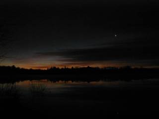
Nov. 19th, 2002, 4:45-6:00AM: What? Dick up early twice, in only two years? It took the promise of a spectacular Leonid meteor storm (and Jill) to do it. Once again, Jill and I drove north from the sky-light pollution belt where we live, to the north shore of Heard Pond in east Wayland.
We didn't see as many meteors as last year. This time, the show was partially washed out by a full moon until first dawn took over, and there was slight misting over the water. (Heard Pond was between us and the much larger Sudbury River). We estimate that we saw 50 to 100 shooting stars. That's 'way down from our 600 to 1,000 at the Leonid showers of 2001, but it still was a morning to remember.
Photo 1- Just before 6AM, the dawn's early light glows along the far shore. That's Venus, the "Morning Star", up in the right. It's cold and it's damp. But it's calm, and the sky is pretty clear after days of clouds and rain. Fair enough.
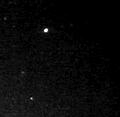
Photo 2- Sorry, we didn't photo any of the tracks we viewed. But, thanks to SpaceWeather.com, here's one from the same shower, as photographed by Jarle Aasland in Stavanger, Norway.
Photo
3- And the movie, taken
by
Bill Gallagher near Lake Tahoe, California. (It's cold up there; if the
movie acts balky before it warms up, you'll understand why. :-)
| Two
years later, on Dec. 16th 2004, we celebrated Beethoven's Birthday (and his great biographer, Alexander Wheelock Thayer) with a presentation by Dick (and a musical presentation by Jon Mitchell) at the Natick Morse Institute Library. Its accompanying (1.2MB) slideshow is online. |
 Alexander
Wheelock Thayer (a classical-music mystery tour in South Natick,
Massachusetts):
Alexander
Wheelock Thayer (a classical-music mystery tour in South Natick,
Massachusetts):
September 25th, 2002: The prior day, Dick and Jill received e-mail from Italian musicologist Luigi Bellofatto, seeking help. Luigi is researching Alexander Wheelock Thayer (1817-1897), who grew up in South Natick, graduated from Harvard College and the Harvard School of Law, and went on to become the greatest biographer of Ludwig von Beethoven - and the U.S. Consul in Trieste, Italy. Luigi provided this photograph of Thayer.
Luigi's request sounded simple enough. He wanted a photograph of the home in which Thayer was born. A half hour or so, right? Wrong. Jill and Dick spent about four hours yesterday and today, visiting the Natick Assessor's Office, the Natick Morse Instute Library, Bacon Free Library in South Natick and the Natick Historical Society's museum in the same building. Then we looked south to the Charles River, east across Pleasant Street, and walked a few houses west on Eliot Street (Route 16) to the old Carver Hill Road, to photograph the early world of Alexander Wheelock Thayer. |
 |
 |
We had already read that
Alexander Wheelock
Thayer's
father
built a house in South Natick in 1816, which was occupied in 1940 by
Charles
E. Hills, physician. In Natick City Directories, we located Doctor
Hills
at 2 Pleasant Street in 1935; he was no longer listed in 1943. 2
Pleasant
Street was also the home of Professor Calvin Stowe and his famous wife,
Harriet Beecher Stowe, who wrote very popular American literature
including
"Uncle Tom's Cabin" about the evils of slavery, and "Old Town Folks"
about
her early days in South Natick.
Above left,
you see a view of 2 Pleasant Street ("The
Stowe
House") from the park entrance, looking across the backyard of the
museum
and library. Then a closer view from the near corner of that yard, and
a view looking north past it along Pleasant Street to the old Eliot
Church, rebuilt several times
but on the site where John Eliot
preached
to the Natick
Praying Indians. Note that
the museum fence is picketed with alternating Indian arrows and
Christian
crosses, a reminder of the Praying Indians who founded Natick here in
1651.


The Stowe House now has a historic sign, which pictures it almost as its present condition. Only a large central chimney has been removed, and two roof dormer windows added.
However, our further research established that, although Alexander Wheelock Thayer's father did build the "Stowe House", it was built for his in-laws.
In 1882 Mrs. Mary P. Richards wrote, "In 1817, Dr. Alexander Thayer of Milford married Susan Bigelow of South Natick and brought his bride to the old Carver House on Eliot Street. Three children were born to them in this house, one of them was Alexander Wheelock Thayer." That was confirmed in a letter Alexander Wheelock Thayer wrote home from Trieste, Italy at Christmas 1894; it was published in the local paper, and said, "My father's house stood on the declivity of Carver's Hill in South Natick. His land extended to the summit, the view from which therefore was familiar to me from earliest childhood."
The old Carver House also had another claim to fame. Jonathan Carver built it in 1738 and left his name on Carver's Hill. This house "was the third wood frame house built by an English settler in the Natick wilderness."
Carver's, and later Thayer's,
home was a
short walk
to
the west on Eliot Street (Route 16), at the east corner of Carver Hill
Road (now Carver Hill Court, no longer going to the top of the hill),
on
the same property as the present 73 Eliot Street. However, the current
house at 73 Eliot Street is newer; it too has a historic marker, which
says, "P. Slamin, 1884". P.H. Slamin razed the old Carver house, after
it had a fire in 1884, and built this next house behind (uphill from)
it
in the same year.
Above left,
the 1798 "Sam Lawton House", which Thayer
describes
as a frequent stop to visit his Grandmother Bigelow. Center, the P.
Slamin
House which replaced (slightly behind) the old Carver House in 1884.
Right,
the same plot of ground, with that house behind a tree.


 Our
request for a photograph of the original "old
Carver House" didn't turn one up in Natick. Luigi Bellofatto found and
forwarded this pre-1884 photo of it, including the same stone wall.
Our
request for a photograph of the original "old
Carver House" didn't turn one up in Natick. Luigi Bellofatto found and
forwarded this pre-1884 photo of it, including the same stone wall.
(This Thayer home photo is from the collection of
Luigi Bellofatto. Reprinted with permission; for reuse, e-mail ibellofatto@alice.it)
To weave all these sites into one, browse on-line with Google Maps. Click here to view the MassGIS orthophoto data in a separate display window while you read on.
In that orthophoto of the center of South Natick, near the upper right you see the intersection of Route 16 (Eliot Street) with a NW-SE road with two names. Northwest of Eliot Street it is Union Street, the road to downtown Natick. Southeast of Eliot Street, it becomes Pleasant Street. Pleasant Street crosses Natick Dam on the Charles River (see the white water on the downstream side of Natick Dam) and disappears at the lower-right side of the photo. 2 Pleasant Street is the first building on the east side of Pleasant; this photo shows that the rear of this building has been expanded greatly (for office space), but you can make out the front (old) building with its two roof dormers facing the street. To its north, in the traffic triangle, is the Eliot Church. Southwest and across Pleasant Street from 2 Pleasant, you see the Bacon Free Library in its own park triangle. And south of that, the park on the Charles River at Natick Dam.
Near the bottom of the view, starting just right of center and curving up, Carver Hill Court runs uphill from Eliot Street; 73 Eliot Street is just north of their intersection. (I'd call it the NE corner of that intersection, assuming Eliot Street runs generally west from Boston.) If you look closely, you can see the tree that hides the house in the rightmost of the above photos, but not in the center photo from directly across Eliot Street.
You can move over or zoom out, using this online MIT orthophoto browser. To zoom out, select a lower resolution level (larger diameter) on the upper left side of the map window.
A color version of this orthophoto also is available online. Unfortunately, its current software which won't permit defining this area of interest as a simple URL. However, now that you have seen the location using this MIT system, you might locate it on the MassGIS Color Orthos. (Click if prompted and then, in the upper right, Choose A Town "Natick". Then click on Route 16 just west of the Wellesley town line. Then find and click on or near the dam on the Charles River, until you've zoomed to taste.)
And that's how one e-mail message turned into two days of research,, online mapping, a pleasant walk and an ever greater appreciation for some later history of this earliest colonial settlement in Natick - and for the fine people who volunteer to preserve its history for future generations.
August 25th, 2002: Dick and Jill explore Douglas State Park, by the tri-corner of Connecticut, Massachusetts and Rhode Island, on a lovely summer Sunday afternoon. The drive is about one hour from Natick via Worcester and highways, and not much more by scenic Route 16 when the traffic is light. A large and well-shaded picnic area away from cars, a spacious rain shelter, and a nice swimming beach on Wallum Lake. It reminds us that Cochituate State Park is capable of great improvements, and that Mass. DEM knows how.
For
us, the big draw  was
the Southern New England Trunkline Trail (SNETT), a one-time railroad
main
line that has become a rail trail. Here is some of it, looking to the
northeast.
The trail's surface is covered with sharp gravel, punctuated with rocks
and an occasional emerging corner of railroad tie, but it will be fine
for hikers, mountain bikes, and the wary bicyclist on less-forgiving
wheels.
The eastern side of the Coffeehouse Loop Trail connects at this point.
It's rougher, with roots and bounces for any biker; some will prefer to
walk this section but it was no problem for our full-suspension
mountain
bikes. (This part of the trail was a spur line to near the present site
of the state park swimming beach; in the days before refrigerators,
this
spur enabled the railroad to ship carloads of Wallum Lake ice from a
six-story
icehouse.)
was
the Southern New England Trunkline Trail (SNETT), a one-time railroad
main
line that has become a rail trail. Here is some of it, looking to the
northeast.
The trail's surface is covered with sharp gravel, punctuated with rocks
and an occasional emerging corner of railroad tie, but it will be fine
for hikers, mountain bikes, and the wary bicyclist on less-forgiving
wheels.
The eastern side of the Coffeehouse Loop Trail connects at this point.
It's rougher, with roots and bounces for any biker; some will prefer to
walk this section but it was no problem for our full-suspension
mountain
bikes. (This part of the trail was a spur line to near the present site
of the state park swimming beach; in the days before refrigerators,
this
spur enabled the railroad to ship carloads of Wallum Lake ice from a
six-story
icehouse.)
 Center
pic: A close-up of Aldrich Pond, barely visible just beyond Jill in the
first pic. It was the millpond for the long-abandoned Aldrich Saw and
Grist
Mill across the trail. The milldam is still in place, but long ago it
was
broken through for the railroad, which slices across the lowered pond
on
its causeway. We poked in the brush just west of here, on the south
side
of the old railroad line, and walked the top of the old dam back to its
spillway. Sure enough, there was the old mill's foundation stonework,
nestled
into the woods and shadows of the far ledge! It seems tiny by modern
standards,
even for a very small mill.
Center
pic: A close-up of Aldrich Pond, barely visible just beyond Jill in the
first pic. It was the millpond for the long-abandoned Aldrich Saw and
Grist
Mill across the trail. The milldam is still in place, but long ago it
was
broken through for the railroad, which slices across the lowered pond
on
its causeway. We poked in the brush just west of here, on the south
side
of the old railroad line, and walked the top of the old dam back to its
spillway. Sure enough, there was the old mill's foundation stonework,
nestled
into the woods and shadows of the far ledge! It seems tiny by modern
standards,
even for a very small mill.
 The
third photo is a little to the west along the SNETT, beyond its
crossing
with the 91-mile, New Hampshire-to-Rhode Island, Mid-State Trail. We're
looking south at a stream crossing (with a too-low side-rail that's
only
safe for cars and ATVs). Seated on the granite wall where Jill is
standing,
we ate in the shade and admired the old stonework, dark-green
iridescent
damsel flies and various dragon flies, darting water-striders, and a
surprising
matched set of big rounded boulders in a quiet pond, each with a small
forest of amazingly ambitious saplings rising up despite no visible
toe-holds.
The
third photo is a little to the west along the SNETT, beyond its
crossing
with the 91-mile, New Hampshire-to-Rhode Island, Mid-State Trail. We're
looking south at a stream crossing (with a too-low side-rail that's
only
safe for cars and ATVs). Seated on the granite wall where Jill is
standing,
we ate in the shade and admired the old stonework, dark-green
iridescent
damsel flies and various dragon flies, darting water-striders, and a
surprising
matched set of big rounded boulders in a quiet pond, each with a small
forest of amazingly ambitious saplings rising up despite no visible
toe-holds.
Douglas
State Park is in the
southeast
corner of 4,640-acre Douglas
State Forest. They offer many
miles of other tempting
trails. We shall return.
June
24-28th, 2002: Off to New
York
City, to review next year's computer products at PC Expo - and for some
side trips as well. Old friends, new computer tricks, unusual food,
reacquaintances
with old streets and subways.


This
year, we visited Dick's
childhood
community of Sunnyside
Gardens in Queens,
NY. This 1925 planned comunity development, just a 15-minute subway
ride
from Grand Central Station, is famous for its sycamore-shaded streets
and
standardized brick row housing with pedestrian alleyways leading into
quiet,
secluded communal courtyards. Close to Manhattan, residential housing
doesn't
get greener than this. The first view is across the street from Dick's
old home. From the alley, that's a view of Dick's old backyard (the day
after a party), a view of it and the shared courtyard behind it, and
finally
a view back from just a little way into that much larger courtyard.


On this trip, we also visited friends in Manhattan and in Westbury on Long Island. We broke up the long drive home with a lovely 1-1/2-hour ferry crossing of Long Island Sound from Port Jefferson to Bridgeport, CT - dodging early-evening storm clouds. And here's a twilight photo approaching the West Rock Tunnel on the Merritt Parkway. Next year, perhaps we'll tote the camera into NYC.
 |
 |
 |
 |
 |
 |
 |
 |
Dec. 25th, 2001: Wintertime, but a lovely and relatively warm day for a hike with old friends: Frank and Edie Sandy and Buzz and Gloria Bloom and the Blooms' dog, Mercy. On this walk through dunes and along the beach, we saw deer footprints, lovely lichens, interesting dried star puffballs and more. One unexpected treat: we saw three snowy owls.
 |
 |
Dec. 3, 2001: On a nice day, we hiked and birdwatched in one of our favorite Audubon sanctuaries. These photos are both at the old beaver dam at the outfall of Little Farm Pond: Jill on the trail bridge at the outfall, and Jill's view from there. |

Nov.
22nd, 2001: We enjoyed
Thanksgiving
Day with some of Dick's cousins and families, at Jerry and Sandy
Kaplan's
home in Gloucester, Massachusetts. A fine afternoon, good company and
real
eatin' food with all the traditional trimmings. Then we all took a fine
walk over Gloucester's Wolf Hill and along its shore. Afterward,
dessert(s),
accompanied by this lovely sunset outside their window.
 |
 |
 |
Nov. 18th, 2001, 4:35-5:30AM: Gasp! Dick up early? It took a spectacular Leonid meteor storm (and Jill) to do it. We estimate that we saw 600 to 1,000 shooting stars, an average of one every two to four seconds during that very special hour. That's our personal best, and we don't expect to surpass it later.
Photo 1- Dick's professional demonstration of why you shouldn't photograph a meteor shower with electronic flash. The grey flying saucers are identified as lens dust - note this powerful particle imaging method. Barely visible in the foreground: Our professional beach laboratory (groundcloth, blankets and down puff) on the shore of Heard Pond.
Photo 2- Dick's professional demonstration of why you should bring a tripod. Low light level (especially while boosting a darker image to this level of brightness) causes long exposure time which causes the shakes, especially on a cold mid-November dawn. A blurry double image of Venus, the morning star, can be seen rising slightly above the treeline, about one-third over from the left.
Photo 3- Some amateur's photo of the same unusual meteor shower. (This image was taken at Yatsugatake Observatory in Japan. Here's another nice one from Taiwan.)
 |
 |
 |
Oct. 28, 2001: We hiked with our friends, Gloria (and Mercy) and Buzz Bloom and Edie and Frank Sandy, for two and a half hours through varied terrain and past numerous small ponds and marshes in the beautiful Estabrook Woods Reservation. We saw beaver footprints in the mud at one of the ponds, near many beaver-chewed trees.
The long-abandoned stone walls and cellar holes reminded us of Henry David Thoreau's fascination with this place, his "Easterbrooks", long ago.
 |
 |
Oct. 20, 2001: Along with many other volunteers, we've been putting a lot of sweat equity into getting the Cochituate Rail Trail open and ready for initial use. After many clean-up days in Framingham since April, here we're breaking through to the Natick town line (at Route 30). |
 |
 |
 |
 |
 |
 |
 |
 |
 |
Sept. 23rd, 2001: Beautiful scenery, both distant and underfoot! We enjoy getting out in the woods for exercise and fresh air. Sometimes we do a little bush whacking, and we always discover a little more about our town.
When completed, this walking trail will connect from Natick Center to the Elm Bank Reservation in South Natick and Dover. It is named after Daniel Takawambpait, the first native minister in New England and perhaps in the New World. (See our "Natick Praying Indians" Web page.)
 |
 |
Jan. 11, 2001: A memorable benefit of Dick's volunteer work with the Mass. Water Resources Authority, we got to tour its massive construction project 400 feet beneath Framingham. MWRA is cutting a new aqueduct to Boston through "solid" rock. Solid it wasn't; it proved to have massive fractures which partially drained Dudley Pond (just north of Lake Cochituate). MWRA is topping up that pond with transfusions of drinking water until the tunnel is completed, sealed and filled with water. |